AI Insight
NASA's Terra satellite captured imagery of a significant dust storm sweeping over Mali on September 5, 2026, during the late summer period when West African dust activity typically decreases. The storm, identified as a haboob driven by strong convective winds, sent aerosols westward toward the Atlantic Ocean, though a full transatlantic crossing was considered unlikely at this time of year. NASA scientists note that the developing El Niño could influence future dust patterns in the Sahel region by altering the Intertropical Convergence Zone and convection patterns, though the relationship between climate phenomena and individual dust events remains complex.
Why it matters
Understanding dust storm patterns in West Africa is important for air quality monitoring, climate modeling, and tracking aerosol transport across the Atlantic, which can affect weather systems, ocean ecosystems, and air quality in distant regions including the Caribbean and Americas. The potential influence of El Niño on dust activity highlights the interconnected nature of global climate systems.
Understand the Science
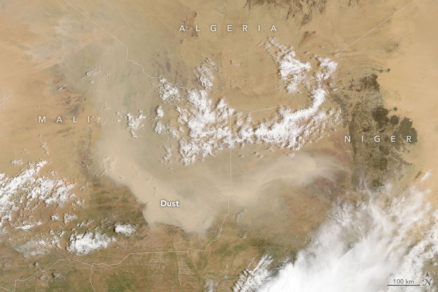
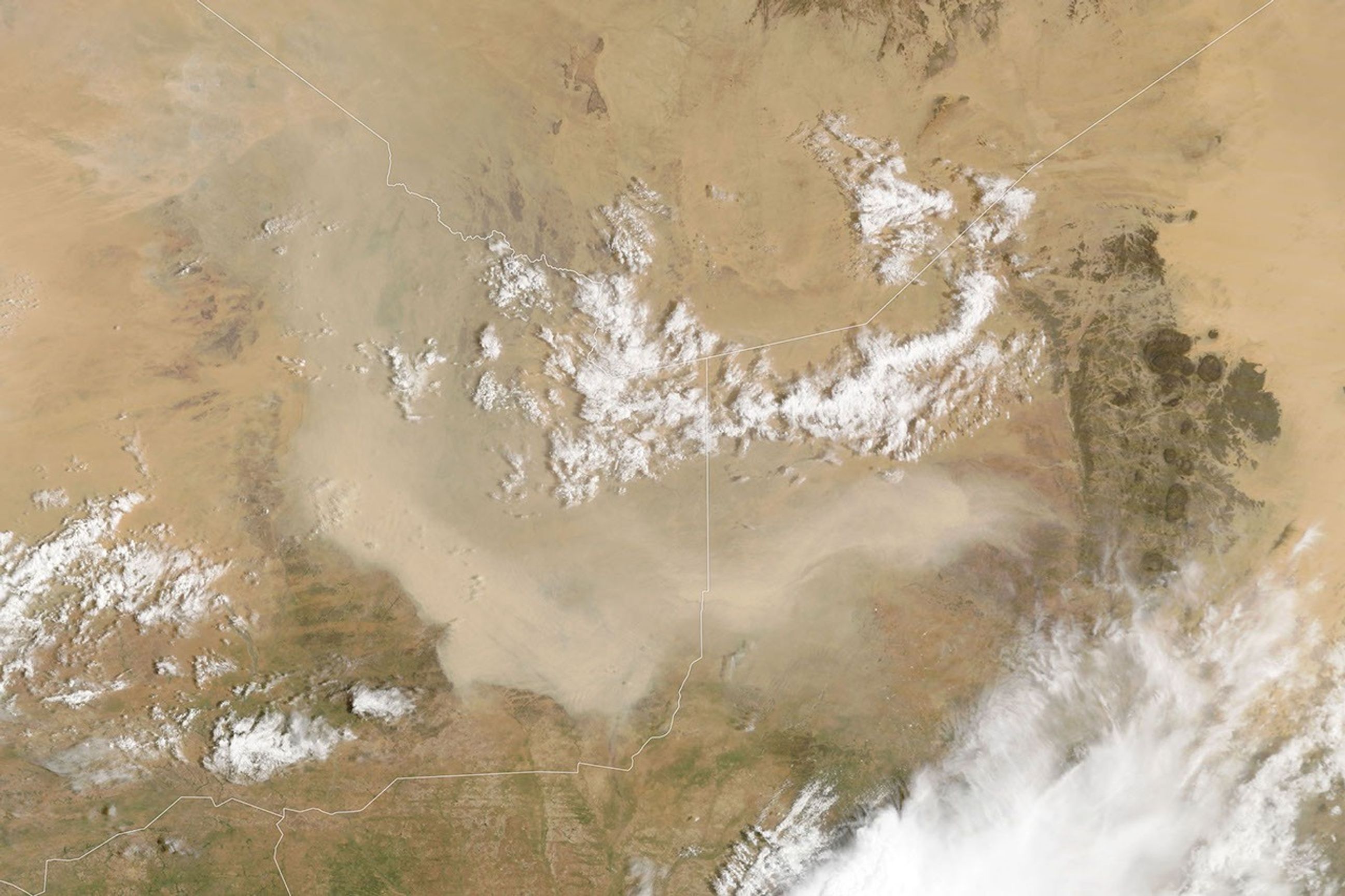
As summer winds down in West Africa, so does much of the region’s dust activity. Dust storms can still occur, though, as one did in early September 2026, when a plume covered parts of Mali and neighboring countries.
The MODIS (Moderate Resolution Imaging Spectroradiometer) on NASA’s Terra satellite captured this image on September 5, 2026. According to Tianle Yuan, an atmospheric scientist at NASA’s Goddard Space Flight Center, storms like this one are often associated with haboobs—powerful dust storms driven by strong convective winds.
In the days after this image was acquired, a wider satellite view showed aerosols from the region moving westward and spilling over the Atlantic Ocean. However, a full transatlantic crossing is unlikely. Such crossings are more common from late spring through summer, when the Saharan Air Layer—a dry, dusty mass of air—can carry dust thousands of miles westward from Africa, riding high in the atmosphere.
Looking ahead, the developing El Niño could reshape these patterns. For instance, Yuan noted that the phenomenon can affect dust over the Sahel and Mali by shifting the Intertropical Convergence Zone and altering convection patterns, though the influence cuts both ways. Drier conditions can leave more loose sediment available for winds to lift, but less convective activity also means fewer intense storms (haboobs) to kick up large dust plumes in the first place. “The connection can be real,” Yuan said, “but hard to pin down for individual events.”
NASA Earth Observatory image by Lauren Dauphin, using MODIS data from NASA EOSDIS LANCE and GIBS/Worldview. Story by Kathryn Hansen.
References & Resources
- NASA Earthdata (2021, April 19) Saharan Dust Versus Atlantic Hurricanes. Accessed September 9, 2026.
- NASA Earth Observatory (2021, June 8) Africa Sheds Some Dust. Accessed September 9, 2026.
- NASA Earth Observatory (2020, January 9) A Dusty Journey. Accessed September 9, 2026.
- NASA Earth Observatory (2001, May 18) From the Dust Bowl to the Sahel. Accessed September 9, 2026.
You may also be interested in:
Stay up-to-date with the latest content from NASA as we explore the universe and discover more about our home planet.
An astronaut’s photo, taken en route to the Moon, reveals our planet and its place in space in a novel…

Your challenge is to tell us the location of the satellite image and why it is interesting.
The Pacific was buzzing with storms while the Atlantic was notably quiet.




Source: Dust Storm Sweeps Over Mali