AI Insight
A new study examining landslide exposure in the United States found that while high landslide susceptibility terrain covers 19% of the country's land area, only 2% of the population (6.5 million people) lives in these zones. The research combined USGS landslide susceptibility maps with data on 128 million structures and social vulnerability metrics to identify exposure patterns. The most exposed populations are concentrated in the Appalachian Highlands and Pacific Mountain System, with 732,000 people in high-risk poverty areas located predominantly in the southern Appalachians.
Why it matters
This research reveals that vulnerable rural communities, particularly in Appalachia, face disproportionate landslide risk due to the intersection of geographic exposure and poverty. The findings can inform targeted mitigation strategies including early warning systems, temporary relocation services, and property acquisition programs in these underserved high-risk areas.
Understand the Science
A new study provides a fascinating insight into the patterns of landslide exposure in the United States.
The increased focus in recent years on the socio-economic aspects of landslides has been welcome. This area of understanding has lagged behind that for other hazards, possibly in part because of the lack on interest from the insurance industry. Increasing evidence of the societal cost of landslides, for example in New Zealand, is shifting the focus.
A really interesting open access paper (Acosta-Reyes et al. 2026) has just been published in the AGU journal Earth’s Future that examines societal exposure to landslides in the United States. This has been reported by some parts of the mainstream media too, which is welcome given that this is a fascinating study.
This study is underpinned by the landslide susceptibility map for the United States developed by the USGS. Acosta-Reyes et al. (2026) have then combined this with two other datasets – an inventory of buildings (the U.S. Army Corps of Engineers (USACE) National Structure Inventory), which includes 128 million structures, and a national scale social vulnerability dataset (the Social Vulnerability Index).
The headlines from the study are important. Whilst terrain with high landslide susceptibility covers 19% of the land area of the United States, only 2% of the population resides within these areas (although this still represents 6.5 million people).
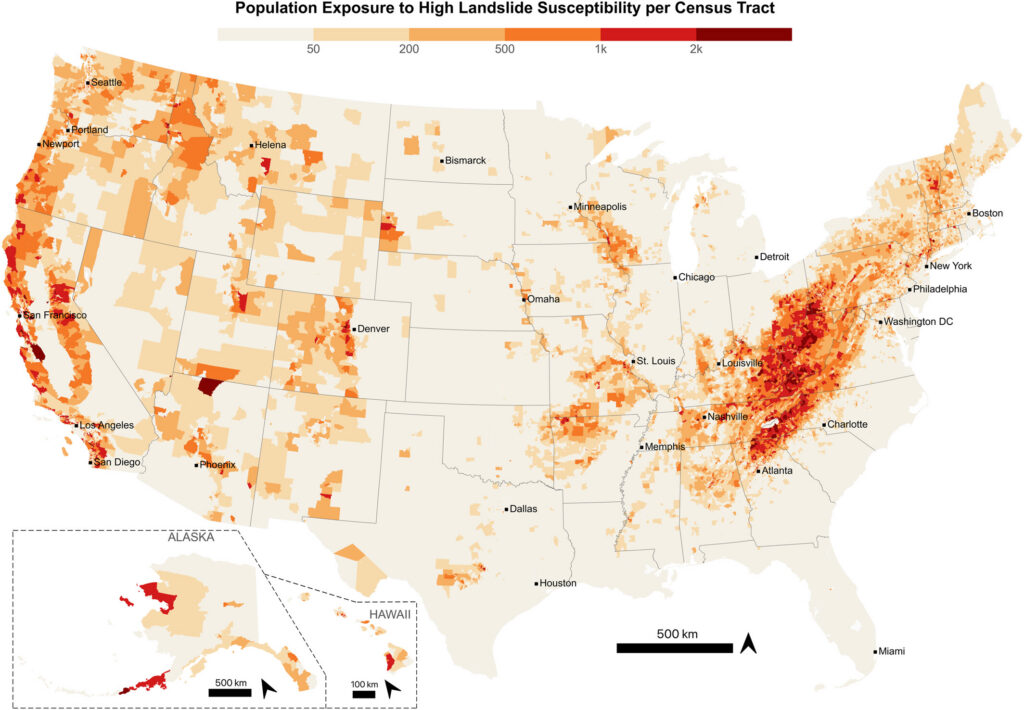
There is huge richness in this study, but allow me to focus on just two elements. First, this map shows the population exposure to high landslide susceptibility:-
This shows that the most exposed populations are in the Appalachian Highlands and in the Pacific Mountain System, with more isolated areas of higher exposure elsewhere across the country.
Second, we know well that poverty greatly increases the potential human outcomes of geophysical hazards – poorer people suffer more from natural hazards. So this map is absolutely fascinating and very important:-
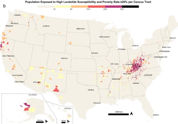
There are 732,000 individuals represented in this map, but the population is hugely concentrated in the southern Appalachians. These are comparatively poor rural communities. Globally, measures to address this exposure to landslides rarely focuses on these communities, but they are so very important.
Acosta-Reyes et al. (2026) consider carefully the policy implications of these highly exposed communities living in poverty:
“Addressing these conditions requires combining hazard mitigation with broader resilience investments: early warning systems tied to precipitation forecasts can reduce harm during extreme rainfall events; temporary relocation services provide immediate protection during acute hazard periods; and for exposed households in high-risk terrain, voluntary property acquisition programs (such as FEMA’s Hazard Mitigation Grant Program) offer a long-term strategy to permanently reduce exposure, an approach already applied in parts of Appalachia for flood hazard with demonstrated benefit-cost ratios … These communities typically lack the local fiscal capacity to implement mitigation measures independently, and without sustained federal and state investment, the gap between exposure and adaptive capacity will remain.”
Translating this into policy change is very difficult, but we now have the information that highlights the need for action.
Reference
Acosta-Reyes, D. et al. 2026. Landslide exposure in the United States. Earth’s Future, e2026EF008622. https://doi.org/10.1029/2026EF008622Digital Object Identifier (DOI)