AI Insight
NASA's NISAR satellite captured an L-band radar image of Nunatak Zaterjavshijsja, a mountaintop in East Antarctica surrounded by flowing ice. The obstruction creates significant stress fractures and deep crevasses in the ice, which appear as sharp green lines in the imagery dubbed "the hummingbird" by scientists. The satellite uses polarized microwave signals to distinguish between smooth ice surfaces (appearing magenta) and irregular fractured surfaces (appearing green), with different polarization returns indicating how the radar waves interact with ice features.
Why it matters
This imaging capability demonstrates NISAR's potential for monitoring ice sheet dynamics, crevasse formation, and glacial flow patterns in polar regions. The dual-frequency radar system could improve understanding of ice stability and contribute to better predictions of sea level rise and climate change impacts.
Understand the Science
NISAR’s L-Band Radar Reveals ‘Hummingbird’ in Antarctica
NASA/JPL-Caltech
Description
Data from the Earth-orbiting U.S.-India NISAR (NASA-ISRO Synthetic Aperture Radar) satellite’s L-band radar was used to produce an image of Nunatak Zaterjavshijsja — a mountaintop in East Antarctica — poking out amid a stream of ice flowing northeast to the ocean. The obstruction causes stresses in the ice, heavily fracturing the surrounding surfaces with deep cracks, called crevasses, which show as sharp green lines in the image. Produced in August 2025, the image has been nicknamed “the hummingbird” by NISAR scientists.
The colors show differences in the way polarized microwave signals, which vibrate in different directions, interact with and reflect from the ice. Over Antarctica, NISAR transmits radar waves toward Earth with a horizontal polarization. The orientation of the signals that return, either horizontal, vertical, or both, provide clues about the object or surface that reflected them.
Signals that come back with a horizontal polarization likely bounced off a more regular surface, such as smooth ice. Those signals appear magenta in the image. Signals that return with vertical polarization may have refracted as they partially penetrated the ice or scattered at different angles as they reflected off irregular surfaces, like the faces of crevasses. Called volume scattering, these observations are displayed in green.
The white represents areas in which both magenta and green signals scatter back strongly, a possible indication that there is an equal blend of surface and volume scattering.
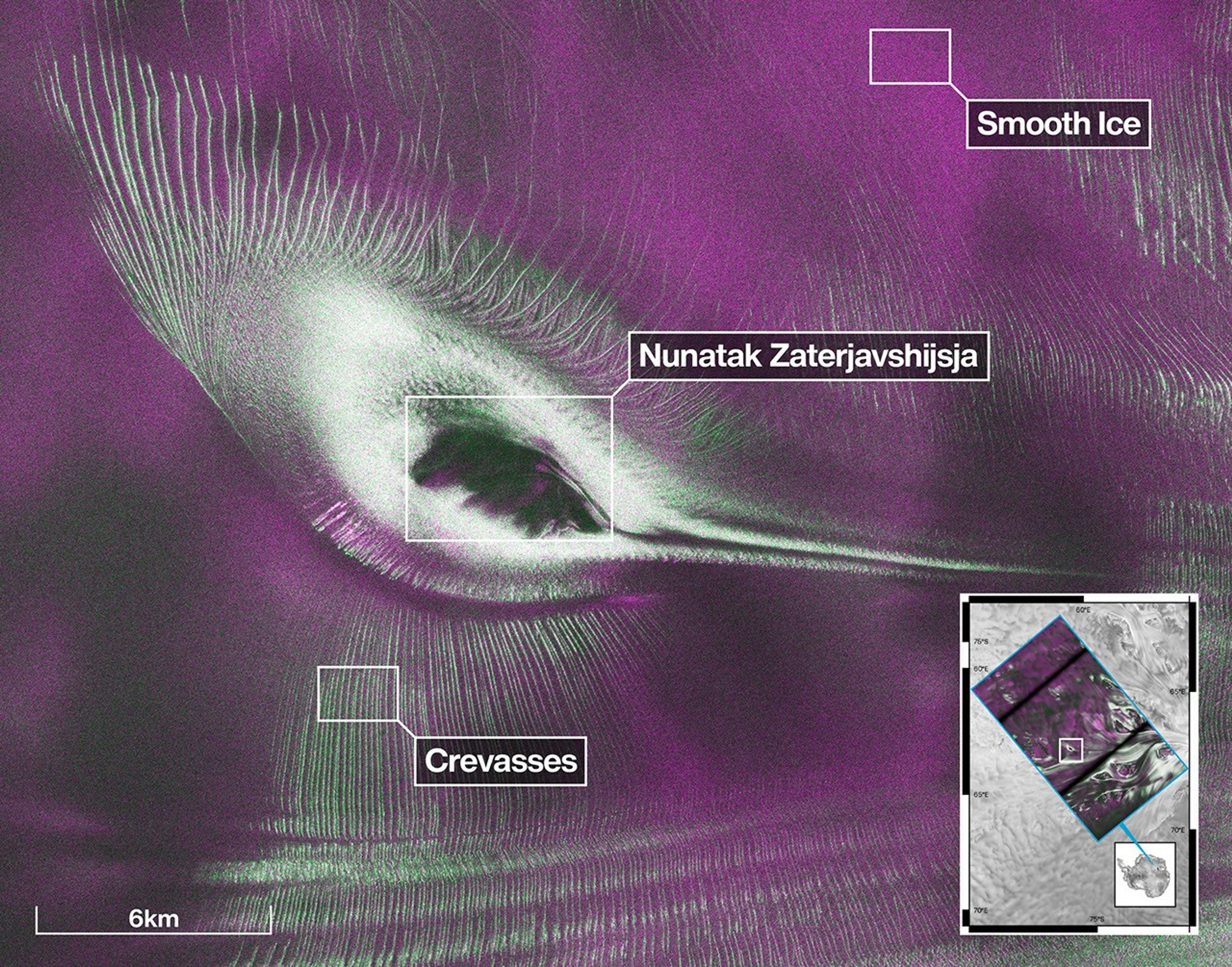
Figure A is an annotated version of image.
Managed by Caltech, NASA’s Jet Propulsion Laboratory leads the United States component of the project and provided the satellite’s L-band SAR and antenna reflector. The spacecraft bus and its S-band SAR were provided by the Indian Space Research Organisation. The NISAR satellite is the first to carry two SAR instruments at different wavelengths, collecting data using the spacecraft’s giant drum-shaped reflector, which measures 39 feet (12 meters) wide — the largest radar antenna reflector NASA has ever sent into space.
To learn more about NISAR, visit:
https://science.nasa.gov/mission/nisar/


Source: NISAR’s L-Band Radar Reveals ‘Hummingbird’ in Antarctica