AI Insight
A comprehensive study of the Eastern and Southern Alps synthesizes decades of research across nine countries to understand the region's slow tectonic deformation. The findings reveal that current movement is primarily driven by a strong crustal block beneath the Dolomites pushing into the Alps, movement between rigid rock blocks, and post-glacial rebound from ice-age glacier melting, while deep mantle processes play a less significant role than previously thought. The highest earthquake hazard zones are identified along the southern Alpine edge and where the Alps meet the Dinarides mountain range.
Why it matters
This research provides a crucial framework for earthquake hazard assessment in slowly deforming regions where weak tectonic signals make risk evaluation particularly challenging. The study will serve as an important reference for understanding similar slow-deformation zones worldwide and improving seismic risk management in the nine-country Alpine region.
Understand the Science
Editors’ Highlights are summaries of recent papers by AGU’s journal editors.
Source: Tectonics
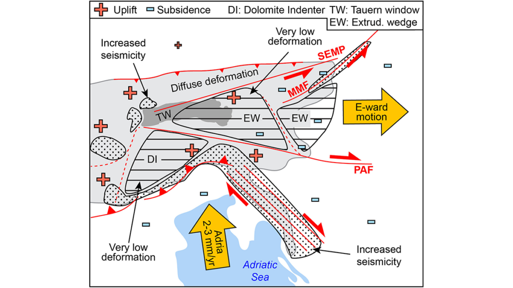
The Eastern and Southern Alps deform slowly compared with many tectonically active regions worldwide, making their ongoing movements especially difficult to detect. Grützner et al. [2026] provide an unusually detailed synthesis of decades of research across nine countries, combining evidence from different datasets, methods, catalogues, and research traditions. By comparing and reconciling these sources, the study creates a comprehensive framework for understanding how active faults and earthquakes relate to climate, the structure of Earth’s outer rocky layer, and deeper processes within the planet.
The results show that present-day deformation is controlled mainly by a strong crustal block beneath the Dolomites pushing into the Alps, movement between relatively rigid blocks of rock, and uplift as the land rebounds following the melting of ice-age glaciers. The slow movement of hot mantle rock deep within Earth appears to play a smaller role than previously proposed. The areas of greatest earthquake hazard are concentrated along the southern edge of the Alps and where the Alps meet the Dinarides. This synthesis will provide an important reference for researchers studying the Alps and other slowly deforming regions, where weak tectonic signals and varied datasets make earthquake-hazard assessment particularly challenging.
Citation: Grützner, C., Petersen, G., Serpelloni, E., Metzger, S., Moernaut, J., Ustaszewski, K., et al. (2026). Active tectonics of the eastern and southern Alps – Crustal response to deep processes? A review. Tectonics, 45, e2025TC009267. https://doi.org/10.1029/2025TC009267
—Lothar Ratschbacher, Associate Editor; and Djordje Grujic, Editor, Tectonics
Text © 2026. The authors. CC BY-NC-ND 3.0
Except where otherwise noted, images are subject to copyright. Any reuse without express permission from the copyright owner is prohibited.
Source: Tectonics and Deglaciation Govern Eastern-Southern Alps at Slow Rates