AI Insight
On October 11, 2026, a major landslide occurred near Chumchet in Nepal's Gorkha district at 4:22 AM local time, creating a natural dam in the Budhi Gandaki River that breached approximately 90 minutes later. The breach triggered a debris flow and flood that traveled downstream, destroying infrastructure including a hydropower project camp, houses, roads, and bridges. Seismic data, helicopter footage, and ground videos suggest the initiating event may have been a highly energetic rock avalanche, evidenced by extensive dust coating on adjacent slopes and possible air blast effects.
Why it matters
This event, which killed five people, raises serious questions about the viability of major infrastructure projects like the planned 225-meter Budhi Gandaki hydropower dam in an increasingly unstable Himalayan region. The incident follows the August 26, 2026 Langtang Lirung event and highlights growing geohazard risks in Himalayan valleys, though successful early warning dissemination appears to have reduced casualties.
Understand the Science
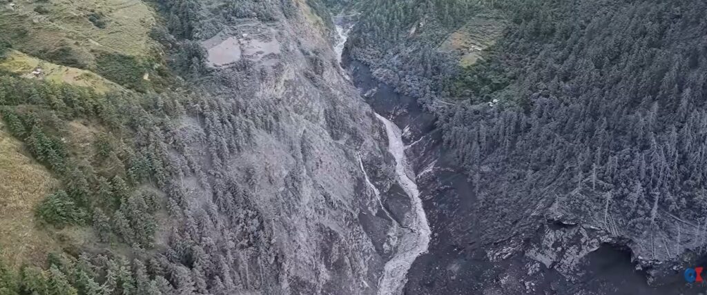
Information is emerging about this major event in Nepal. Helicopter video suggests that it was initiated by a very dynamic landslide – possibly a rock avalanche?

On 11 October 2026, yet another major debris flow/flood occurred in Nepal, sweeping down the Budhi Gandaki River in Gorkha district. This has caused substantial damage, although not on the scale of the 26 August 2026 Langtang Lirung event. This flow travelled rather more slowly and it was smaller. There also appears to have been successful dissemination of warnings.
There is a very good video circulating on social media – this is a version on Youtube:-
Seismic data posted to Bluesky by Kristen Cook records a landslide, thought to be in the vicinity of Chumchet, at 04:22 local time, followed by a breach of the landslide dam at about 6 am. This is the cause of the debris flow/flood that swept downstream. Chumchet is located at [28.4755, 84.9644].
There is also a video collected from a helicopter showing the aftermath of the landslide, posted by Online Khabar. This is very interesting (note that the automatic translation has failed though, creating very odd subtitles):-
This captures the upper track of the debris flow. There appears to have been a huge amount of dust generated that has coated the adjacent slopes:-
There may even be some evidence of an air blast at around 53 seconds into the video. So was this a rock avalanche?
In terms of losses, it appears that five people have probably been killed, and there has been damage to houses, roads and bridges. The video at the top of the post shows the destruction of a camp for the Budhi Gandaki hydropower project. This will be a 225 metre high dam – one wonders if this project is viable in light of events this summer.
Hopefully, in the coming days better satellite and aerial imagery will emerge that will allow this event to be analysed properly. In the meantime, it serves to highlight once again the major issues that are emerging along Himalayan valleys.