AI Insight
A magnitude 7.8 earthquake struck offshore Mindanao, Philippines on June 8, 2026, triggering multiple fatal landslides across the region. The most severe landslide occurred in New Aklan, Glan, Sarangani, killing 13 people, while another landslide at Sitio Buhangin, Barangay Patuco trapped four missing individuals beneath a coastal cliff failure. Initial reports indicate at least 17 combined fatalities, though the remote locations of affected areas mean complete information is still emerging.
Why it matters
This event demonstrates the significant secondary hazards posed by earthquake-triggered landslides in mountainous coastal regions of the Philippines. The incident highlights the need for improved landslide risk assessment and early warning systems in seismically active areas where steep terrain and populated communities intersect.
To date news reports suggest two fatal landslides with a combined toll of 17 people.

There are various news reports trickling in about the landslides triggered by the 8 June 2026 M=7.8 earthquake offshore Mindanao in the Philippines. As usual, the remote locations of many of the landslides means that the information is a bit hit and miss at this point.
To date, the most serious event appears to have occurred at a community called New Aklan, located in Glan, Sarangani. It appears that New Aklan is at: [5.7705 N, 125.3356]. News reports indicate that 13 people were killed, although there are also indications of additional fatalities in this area.
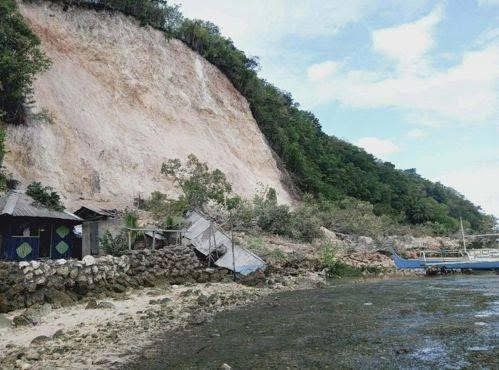
A further four people are missing under a landslide at Sitio Buhangin, Barangay Patuco, Sarangani. Patuco is in the area of [5.4770, 125.4859]. This appears to have been a failure on a coastal cliff:-
Over the next few days, satellite imagery should become available that will help identify the landslide impacts, but in the meantime Dan Shugar has identified some (using Planet imagery, I’d imagine):-